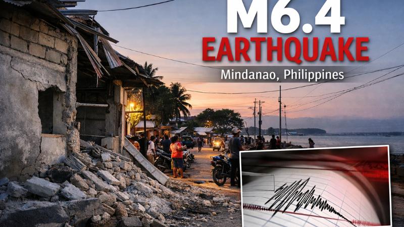
A powerful earthquake measuring magnitude 6.4 struck offshore near the town of Baculin in the southern Philippines on Wednesday, January 7, underscoring the persistent seismic risks faced by communities in the region. The earthquake occurred at sea, approximately 58.5 kilometers from the nearest coastline and around 27 kilometers east of the town of Santiago on the island of Mindanao. The tremor was felt across parts of eastern Mindanao, prompting heightened monitoring by authorities, though no immediate reports of casualties or structural damage were received in the hours following the event.
According to seismic data, the earthquake originated beneath the seabed, reducing the likelihood of widespread destruction on land. The country’s seismology agency advised residents in nearby areas to remain alert, noting that damage assessments were ongoing and that aftershocks were possible in the aftermath of the main quake. Despite the strength of the tremor, officials confirmed that there was no tsunami threat, and coastal communities were not ordered to evacuate.
Initial readings had placed the earthquake at a higher magnitude before it was later revised downward following further analysis. Such adjustments are common as more detailed seismic data becomes available after strong earthquakes, particularly those occurring offshore. Emergency response units and local authorities continued to monitor the situation, while residents were urged to follow standard earthquake safety guidelines in case of subsequent tremors.
The latest quake comes amid a history of significant seismic activity in Mindanao and other parts of the Philippines. In October, eastern Mindanao experienced two major earthquakes measuring magnitudes 7.4 and 6.7, which resulted in at least eight fatalities and caused extensive damage in affected areas. Earlier seismic disasters in the country have had even more severe consequences. A magnitude 6.9 earthquake in Cebu province in central Philippines previously claimed dozens of lives and damaged or destroyed tens of thousands of homes, highlighting the vulnerability of communities to strong ground shaking.
The Philippines is located along the Pacific Ring of Fire, a vast arc of tectonic boundaries stretching from Japan through Southeast Asia and across the Pacific basin. This geological setting makes the country one of the most earthquake-prone regions in the world, with frequent seismic events ranging from mild tremors to devastating earthquakes. While many quakes cause little to no damage, stronger events pose serious risks, particularly in densely populated or poorly reinforced areas.
Authorities continue to emphasize preparedness and public awareness as essential measures in reducing the impact of earthquakes. Ongoing monitoring, updated building standards, and timely dissemination of information remain critical in a nation where seismic activity is a regular occurrence. As assessments continue following the Baculin-area quake, officials stress that vigilance is necessary, even in the absence of immediate damage, given the unpredictable nature of aftershocks and future seismic events.