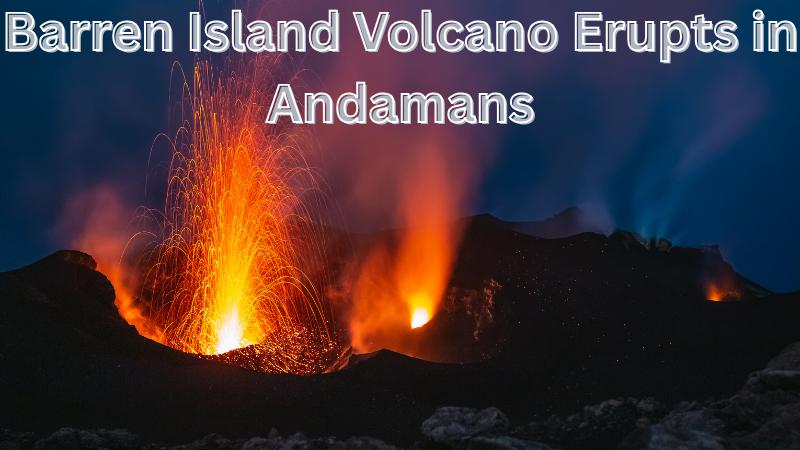
India’s only active volcano, Barren Island in the Andaman and Nicobar archipelago, erupted once again this month, sending molten lava streams and thick smoke into the sky. The eruption, captured by an Indian Navy warship, showed glowing lava flows cascading down its slopes while plumes of smoke billowed from the summit. Though the eruption created spectacular visuals, scientists emphasize it is a reminder of the powerful geological forces at work beneath the Indian Ocean region.
The volcanic activity at Barren Island is deeply tied to its unique geological setting. The island lies along the Andaman-Nicobar arc, which forms part of a subduction zone where the Indo-Australian plate is pushed beneath the Eurasian (Sunda) plate. This tectonic collision drives earthquakes and creates channels through which magma rises to the surface.
The latest eruption was likely triggered by increased seismic activity in the magma chamber beneath the volcano. Frequent earthquakes, both micro and moderate, rupture rocks around the magma reservoir, releasing pressure and allowing molten rock and volcanic gases to escape. This process set off the minor explosion observed, which caused glowing lava flows and tremors across nearby regions.
Barren Island measures about 3.2 km across and rises nearly 2 km above the ocean floor, with its summit standing 300–354 meters above sea level. The volcano remained dormant for nearly 150 years before erupting in 1991. Since then, it has displayed intermittent activity, including eruptions between 2017 and 2019.
The current eruption poses no immediate threat due to the island’s uninhabited status. However, maritime advisories have been issued by the Indian Navy and Coast Guard to ensure safe navigation for vessels passing nearby. Meanwhile, geological teams from the National Centre for Seismology and the Geological Survey of India are closely analyzing seismic and satellite data to better understand the eruption and assess any future risks.
For India, Barren Island’s activity highlights the ongoing influence of tectonic forces shaping the Andaman and Nicobar Islands. It underscores the importance of continued monitoring of natural hazards in this sensitive region, where earthquakes and volcanic activity remain a constant reminder of Earth’s dynamic nature.