A powerful and expansive winter storm is forecast to sweep across large portions of the United States from Friday through Monday, bringing a dangerous mix of heavy snow, sleet and freezing rain to millions across the South, Midwest and Northeast. The system, known as Winter Storm Fern, is expected to impact more than 180 million people as it stretches from New Mexico and Texas to parts of New England, creating hazardous travel conditions and raising the risk of widespread power outages.
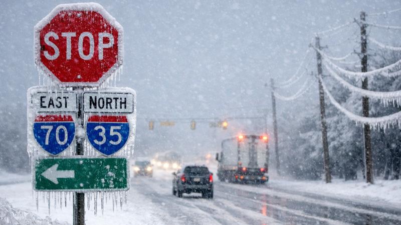
Winter storm watches are already in place across parts of the southern Plains and into the Southeast, with additional alerts likely to be issued as the system intensifies and shifts eastward. The most severe impacts are anticipated in areas where prolonged freezing rain and heavy snowfall overlap, increasing the likelihood of impassable roads, downed trees and damage to power infrastructure.
The storm is expected to begin affecting the Plains by Friday, with snow, sleet and freezing rain developing by late morning or early afternoon in portions of Kansas, Oklahoma, northern and western Texas and parts of Arkansas. As the day progresses into Friday night, wintry precipitation is forecast to expand southward across the southern Plains and lower Mississippi Valley while spreading east into the Tennessee Valley and the southern Appalachians.
By Saturday, the storm is likely to intensify across a broad region, with icy conditions extending deeper into Texas, Louisiana and Mississippi, while heavier snow becomes more widespread across Kentucky, Tennessee, West Virginia, Virginia and sections of the Carolinas. Saturday night into early Sunday may bring further expansion of snow into the mid-Atlantic, with accumulating snowfall possible from Washington, D.C., northward through major Northeast corridors.
Wintry precipitation is expected to taper off across Texas, Oklahoma and the lower Mississippi Valley by midday Sunday. However, snow and ice are likely to persist from the Ohio Valley through the Mid-Atlantic and into the Northeast, where some locations could see significant snowfall totals. Gusty winds combined with snow may further reduce visibility and complicate travel into Sunday night and early Monday.
Ice accumulation poses one of the greatest threats across parts of the South, where freezing rain could coat roads, trees and power lines. Even modest ice buildup can lead to dangerous driving conditions and increase the risk of extended power outages. Forecast uncertainty remains regarding the exact placement of the rain-freezing rain boundary, as small temperature changes could significantly alter impacts in the Southeast.
Snowfall totals are still being refined, but a broad swath from the southern Plains to the Northeast is increasingly likely to receive substantial accumulations. The Interstate 95 corridor from the mid-Atlantic into southern New England faces a heightened risk of disruptive snowfall, which could trigger widespread travel delays and flight cancellations, particularly late Sunday and early Monday.
Compounding the storm’s effects is a surge of arctic air expected to follow closely behind the system. Temperatures across the South, Midwest and East may plunge to levels capable of challenging daily cold records. In areas affected by snow and ice, daytime highs may remain below freezing into early next week, with overnight lows dropping into the single digits, teens and lower 20s. These conditions could prolong hazardous travel and create dangerous situations for communities experiencing power outages.
The atmospheric setup driving this storm includes a strong arctic high pressure system delivering cold air deep into the southern United States, combined with a moisture-rich storm system emerging from the Southwest. As moisture moves northward into increasingly cold air, conditions become favorable for widespread winter weather.
Residents across the affected regions are urged to monitor forecasts closely and prepare for rapidly changing conditions, including the potential for extended travel disruptions and prolonged cold following the storm’s passage.