As Central Texas braces for another round of early May storms, experts warn that the region’s most dangerous weather is yet to come. While May is traditionally known as the peak of severe weather season bringing thunderstorms, hail, and tornadoes flash flood season officially reaches its height in June, according to data from the National Weather Service (NWS).
Between 1996 and 2020, South Central Texas reported 498 flash flood incidents in May, 506 in June, and 430 in July. These three months consistently record the highest flash flooding activity in the region, with June narrowly topping the list. Despite the current severe weather alerts and rainfall, Central Texas has so far experienced only minimal flash flooding. But that could change quickly as storm systems strengthen and summer rainfall patterns intensify.
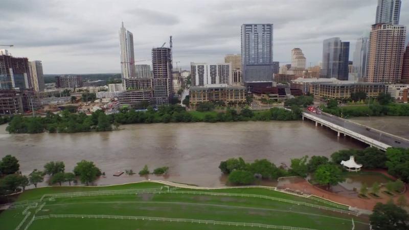
The region’s topography and soil composition contribute significantly to the risk. Central Texas, particularly the Interstate 35 corridor stretching from Austin through San Antonio, is known as "Flash Flood Alley" due to its vulnerability to sudden, intense flooding. Urban development, limited drainage infrastructure, and sloping terrain make it easy for heavy rain to pool and flow rapidly, overwhelming streets and streams in a matter of minutes.
Adding to the seasonal danger, Central Texas also experiences a secondary flash flood season from August through October, primarily driven by tropical storms and hurricanes. October stands out as the peak of this secondary season, followed by a sharp drop in flood incidents in November. The tropical rains that come during hurricane season often linger, contributing to flash flooding long after landfall.
To help assess and communicate flood threats, the Weather Prediction Center uses a four-tier scale to classify excessive rainfall risk:
-
Level 1 (Marginal Risk)
-
Level 2 (Slight Risk)
-
Level 3 (Moderate Risk)
-
Level 4 (High Risk)
Central Texas frequently experiences Level 1 and Level 2 events, but a Level 3 Moderate Risk is especially serious. Data show that, on average, one in four moderate-risk flood days results in a flood-related injury or death, and one in three causes at least $1 million in property damage. Central Texas sees about six of these high-impact days each year, underscoring the ongoing threat even outside hurricane season.
Preparing for Flash Flooding in Flash Flood Alley
Because flash flooding in Central Texas can happen with little notice, preparation is essential. The NWS typically issues a Flood Watch when conditions are favorable for flash flooding. Residents are advised to monitor local forecasts closely during these periods, especially in low-lying areas or places with poor drainage systems.
Key safety tips include:
-
Avoid driving through flooded roadways. Just six inches of moving water can knock over an adult, and one foot of water can sweep away a vehicle.
-
Turn around, don’t drown. This simple but effective phrase from emergency services is a critical reminder during heavy rainfall.
-
Stay informed. Use trusted weather apps, NOAA radio, or local news channels like KXAN to stay updated on watches, warnings, and radar data.
-
Create an emergency kit. Flash floods can disrupt power and water services. A kit with flashlights, bottled water, first-aid supplies, and important documents is recommended.
-
Secure outdoor items. Trash bins, furniture, and yard equipment can become hazardous in high water.
Flash flooding doesn’t just damage property it can be deadly. A heatmap from the National Oceanic and Atmospheric Administration (NOAA) highlights Central Texas as one of the nation’s most affected regions for deadly flood events. The urban sprawl around Austin, San Antonio, and surrounding suburbs makes the danger even more pronounced as runoff builds quickly.
With storms forecast to continue through midweek, residents are advised to remain alert and follow all local advisories. The First Warning Weather Team at KXAN will continue to provide around-the-clock coverage as weather patterns develop. The transition from May's severe storm season into June’s flash flood season marks a critical time for preparedness in Central Texas. Whether dealing with isolated thunderstorms or the fallout from tropical systems, knowing the risks and how to respond can make all the difference.