Edit

Severe Storms to Hit Dallas-Fort Worth Overnight: Hail, Winds, and Flood Risk

Severe Storms to Hit Dallas-Fort Worth Overnight: Hail, Winds, and Flood Risk
Dallas-Fort Worth residents are urged to stay alert as multiple rounds of severe thunderstorms are forecasted to impact the region from Saturday evening into early Sunday morning. According to the National Weather Service, the storms could bring hail up to 2–3 inches, wind gusts over 60 mph, localized flooding, and even a low risk of tornadoes—particularly if storms develop ahead of the main line.

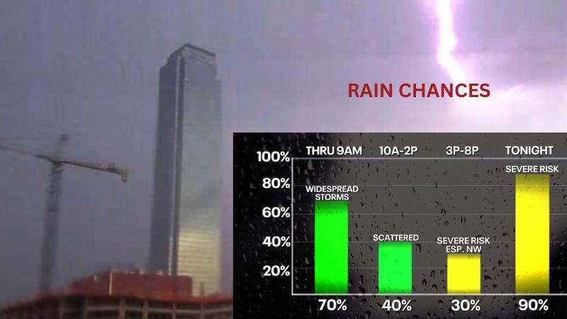
A Flood Watch is in effect for parts of western North Texas—including Cooke, Montague, Jack, and Young counties—from 1 AM Saturday to 1 PM Sunday.
Looking ahead to Easter Sunday, showers and thunderstorms may continue into the morning, potentially disrupting early plans. However, weather conditions are expected to improve by afternoon, with clearing skies and highs in the mid-70s accompanied by breezy west winds.

Residents are advised to:
  • Monitor real-time weather alerts
  • Secure outdoor furniture and loose items
  • Prepare for possible power outages
  • Drive carefully in low-visibility or flooded areas

What is your response?

joyful Joyful 0%
cool Cool 0%
thrilled Thrilled 0%
upset Upset 0%
unhappy Unhappy 0%
AD
AD
AD