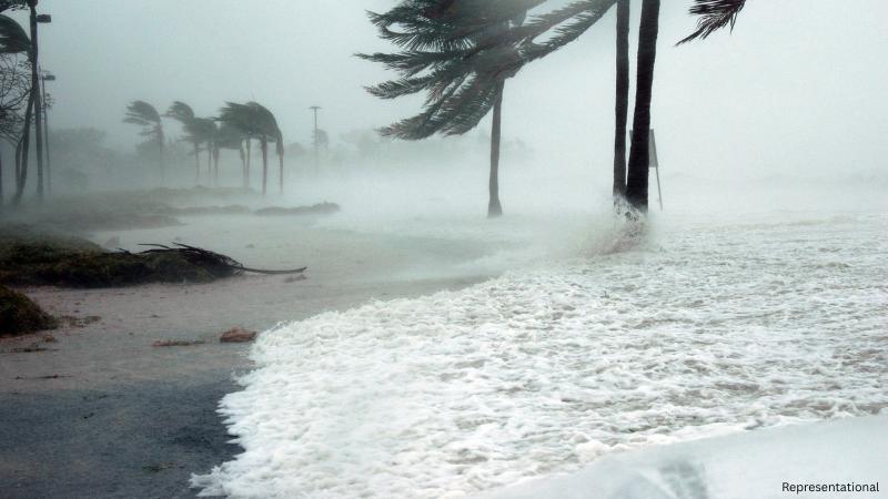
New Jersey is preparing for the arrival of Hurricane Erin, which is expected to bring heavy rains, strong winds, coastal flooding, and significant beach erosion to the state. As the Atlantic storm system moves closer, local authorities and weather experts have issued alerts, urging residents to stay vigilant and avoid vulnerable areas along the shoreline. The concern comes as ocean swells and storm surges are likely to impact low-lying communities, particularly those near inlets and barrier islands that historically experience severe erosion during hurricanes and tropical storms.
Hurricane Erin has been steadily strengthening over the Atlantic, and although its exact track is still under monitoring, forecasters warn that the storm’s wide reach means New Jersey will face impacts regardless of a direct landfall. Coastal towns are particularly at risk, with waves expected to pound beaches and storm surges raising water levels that could flood homes, businesses, and roadways. Experts say that storm-related flooding can be just as destructive as wind damage, and early preparation will be key for residents living in affected areas.
One of the major risks that officials are highlighting is beach erosion. New Jersey’s coastline, already vulnerable from years of natural wear and previous storms, is expected to lose significant sand cover as pounding surf pushes inland. Communities on the south side of coastal inlets are especially at risk, with erosion rates predicted to rise sharply once the storm surge builds. This poses not only an immediate risk to homes and businesses but also long-term concerns for tourism, property values, and shoreline stability.
Residents are being strongly advised to avoid traveling near the oceanfront during the storm. Observing the waves, though tempting, can be dangerous due to sudden surges and the possibility of collapsing dunes. Local officials have emphasized that strong waves can carry debris, further increasing risks for those standing near the shoreline. Emergency services are on standby, and coastal towns have begun implementing precautionary measures including monitoring evacuation zones, preparing sandbag barriers, and restricting access to particularly dangerous stretches of beach.
The storm is also expected to disrupt travel and local businesses in the coming days. With potential flooding of highways, rail lines, and local roads, commuters may face delays, while coastal shops and restaurants could see closures until the system passes. Authorities are warning that residents should stock up on essentials, charge devices, and have emergency kits ready in case of power outages. Flash flooding inland is also a concern as rainfall could overwhelm drainage systems in some towns.
Hurricane Erin is not the first storm to test New Jersey’s preparedness, and lessons learned from past hurricanes like Sandy remain fresh in memory. Officials say infrastructure has been reinforced, but every storm brings unique challenges. The public is being urged to heed warnings, follow evacuation orders if issued, and use extreme caution in the days ahead. Safety should remain the top priority, as property can be replaced, but lives cannot.
Meteorologists continue to track the storm’s path, and updates will be issued regularly as Erin moves closer. While forecasts are subject to change, the current models indicate that New Jersey will face rough seas, elevated tides, and possible flooding in multiple counties. Preparedness and caution will play a key role in minimizing damage and ensuring community resilience.
As New Jersey braces for Hurricane Erin, the state stands at a critical moment where planning, communication, and collective action can help weather the storm. Residents are reminded to check official weather updates, stay informed through local authorities, and remain indoors during the storm to ensure their safety. Hurricane Erin’s impact may be significant, but with timely action and awareness, the state hopes to reduce risks and recover swiftly once the storm has passed.